|
ENGINEERING HYDROLOGY: CHAPTER 053 - ESTIMATION OF CURVE NUMBERS
1. CURVE NUMBERS
1.01
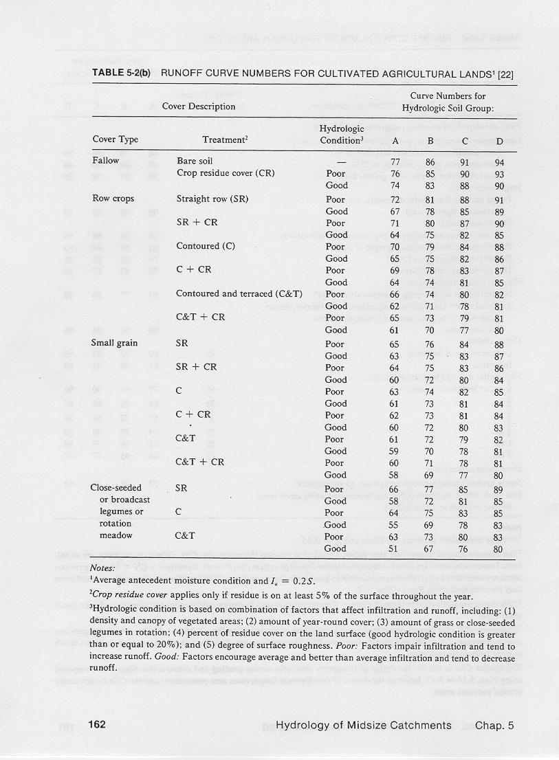
For ungaged watersheds, estimates of curve numbers are given in
standard tables supplied by federal agencies, and local city and county
departments.
1.02
Tables of runoff curve numbers for various hydrologic soil-cover complexes
are widely available.
1.03
1.04
The hydrologic soil-cover complex describes a specific combination of
(a) hydrologic soil group,
(b) land use and treatment,
(c) hydrologic surface condition,
and
(d) antecedent moisture condition.
1.05
All these have a direct bearing on the amount of runoff produced by the watershed.
1.06
The hydrologic soil group describes the type of soil.
1.07
The land use and treatment describes the type and condition of the vegetative cover.
1.08
The hydrologic surface condition refers to the ability of the watershed surface to enhance or impede runoff.
1.09
The antecedent moisture condition accounts for the recent history of rainfall and, consequently, it is a measure of the watershed's ability to store
additional moisture.
2. HYDROLOGIC SOIL GROUPS
2.01
All soils are classified into four hydrologic soil groups of distinct runoff-producing properties.
2.02
These groups are labeled A, B, C, and D.
2.03
Group A consists of soils of low runoff potential, having high infiltration rates even when wetted thoroughly.
2.04
They are primarily very well drained sands and gravels, with a characteristically high rate of water transmission.
2.05
Group B consists of soils with moderate infiltration rates when wetted thoroughly,
with moderately fine to moderately coarse textures.
2.06
These soils have a moderate rate of water transmission, typically silty loams or loams.
2.07
Group C consists of soils with slow infiltration rate when wetted thoroughly, with moderately fine to fine texture.
2.08
These soils have a slow rate of water transmission, typically sandy clay loams.
2.09
Group D consists of soils of high runoff potential, having very slow infiltration rates when wetted thoroughly.
2.10
These soils have a very slow rate of water transmission, typically clay loams, or soils with a high water table.
2.11
Maps showing the geographical distribution of hydrologic soil types are available for most areas in the United States.
2.12
Hydrologic
soil type | Rate of water transmission | Texture
|
| A
| High
| gravel, sand, sandy loam
|
| B
| Moderate
| Silty loam, loam
|
| C
| Slow
| Sandy clay loam
|
| D
| Very slow
| Clay loam, silty clay loam
|
3. LAND USE AND TREATMENT
3.01
Land use pertains to the watershed cover, including vegetation, litter and mulch, fallow,
as well as nonagricultural uses such as water surfaces and impervious surfaces.
3.02
Land treatment applies mainly to agricultural land uses, and it includes mechanical practices
such as contouring or terracing, and management practices such as grazing control and crop rotation.
3.03
A class of land use/treatment is a combination often found in a catchment.
3.04
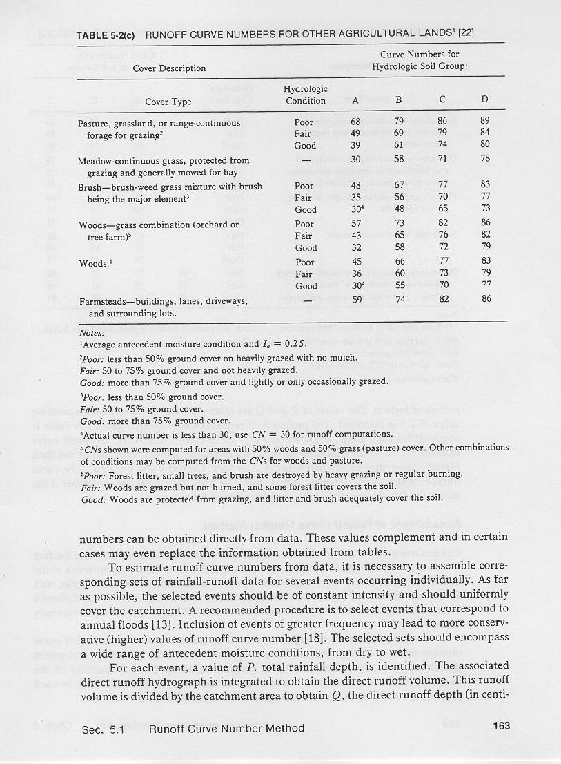
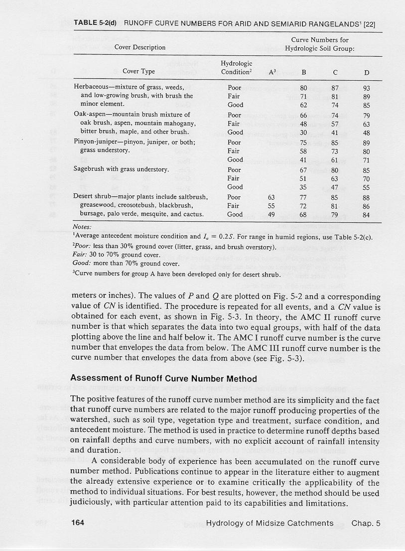
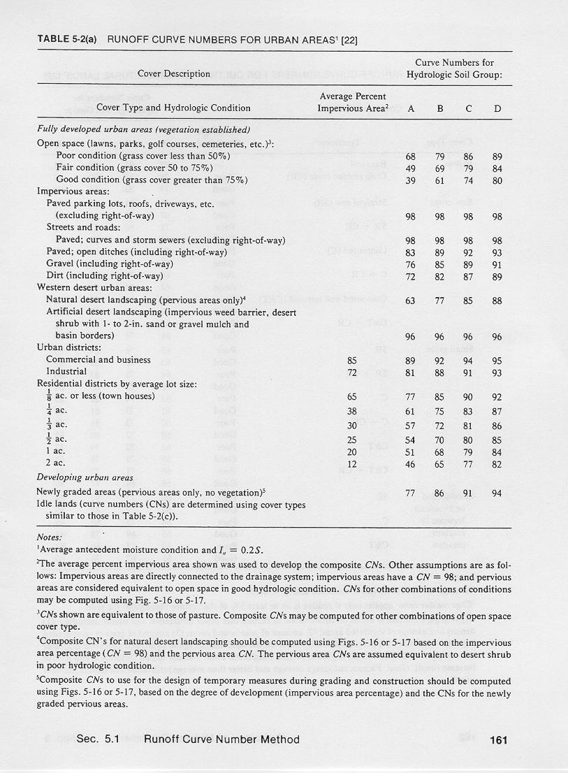
The curve number method distinguishes between croplands, grasslands, woods and forests.
3.05
Standard curve number tables are available for various land use/treatment classes.
3.06
3.07
3.08
4. HYDROLOGIC SURFACE CONDITION
4.01
The hydrologic surface condition can be classified as: (a) poor, (b) fair, and (c) good.
4.02
Grasslands are evaluated by the hydrologic condition of native pasture.
4.03
The percent of aerial coverage by native pasture and the intensity of grazing are visually estimated.
4.04
A poor hydrologic condition describes less than 50 percent aerial coverage and heavy grazing.
4.05
A fair hydrologic condition describes 50-75 percent aerial coverage and medium grazing.
4.06
A good hydrologic condition describes more than 75 percent aerial coverage and light grazing.
4.07
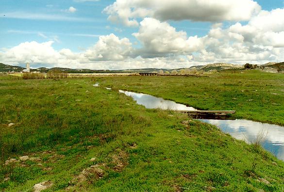
Campo valley, San Diego County, California.
4.08
The hydrologic condition of woods is also visually estimated.
4.09
A poor hydrologic condition describes heavily grazed or regularly burned woods, with very little litter and few shrubs.
4.10
A fair hydrologic condition describes woods that are grazed but not burned, with moderate litter and some shrubs.
4.11
A good hydrologic condition describes woods that are protected from grazing, with heavy litter and many shrubs covering the surface.
4.12
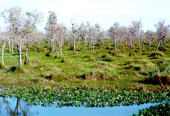
Flood plain near Corumba, Mato Grosso do Sul, Brazil.
5. ANTECEDENT MOISTURE CONDITION
5.01
Antecedent moisture is the moisture already present in the soil at the onset of the precipitation event.
5.02
The runoff curve number method recognizes the importance of antecedent moisture in determining runoff.
5.03
Three levels of antecedent moisture are defined: (1) dry, (2) average, and (3) wet.
5.04
The dry antecedent moisture condition AMC I has the lowest runoff potential.
5.05
The average antecedent moisture condition AMC II has average runoff potential.
5.06
The wet antecedent moisture condition AMC III has the highest runoff potential.
5.07
The chosen AMC level for design is specified by county hydrology manuals or estimated from experience.
5.08
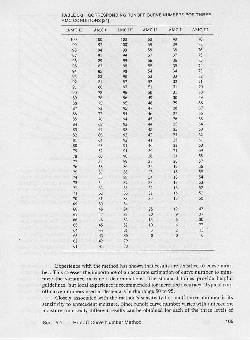
The curve numbers shown in standard tables correspond to AMC II.
5.09
NRCS publishes a table to convert from AMC II to AMC I and AMC III.
5.10
6. ASSESSMENT
6.01
The curve numbers are related to the following major runoff-producing watershed properties: (a) soil type, (b) land use and treatment, (c) surface condition, and (d) antecedent moisture.
6.02
The method determines runoff depths based on rainfall depths and curve numbers, with no explicit account of rainfall intensity.
6.03
For best results, the method should be used judiciously, with particular attention to its capabilities and limitations.
6.04
The method is sensitive to the choice of curve number.
6.05
The standard tables provide helpful guidelines, but local experience is recommended for increased accuracy.
6.06
Typical runoff curve numbers used in urban drainage design are in the range 50-95.
6.07
The method's marked sensitivity to antecedent moisture reflects the conditions likely to be encountered in actual practice.
6.08
The method is essentially a conceptual model to estimate runoff volumes based on established hydrologic abstraction mechanisms.
6.09
It was developed to calculate runoff volumes produced by individual storms.
6.10
Therefore, caution is recommended when using the method for applications that reach beyond its originally intended purpose.
Narrator: Victor M. Ponce
Music: Fernando Oñate
Editor: Flor Pérez
Copyright © 2011
Visualab Productions
All rights reserved
| 


