GUYANA COASTAL FLOOD PROTECTION PROGRAM
REHABILITATION OF THE EAST DEMERARA AND BOERASIRIE WATER CONSERVANCIES
ASSESSMENT AND PLAN OR WORK
VICTOR M. PONCE, CONSULTANT
25 JULY 2006
The coastal regions of Guyana have recently experienced two consecutive January seasons of heavy rainfall (2005 and 2006),
which resulted in extensive flooding. Thousands of people were driven from their homes, and the entire
population was affected in some way. The flooding is exacerbated by an unusual combination of natural and human-induced causes.
Large areas of the coastal regions lie at or below sea level, making it difficult for floodwaters to drain.
In Guyana's Regions 3 (West Demerara) and 4 (East Demerara), there are two large manmade reservoirs, referred to as
the Boerasirie and East Demerara Water Conservancies, respectively. These serve the dual
purpose of protecting downstream areas from flooding during the two annual wet seasons, and storing floodwaters for intensive cash-crop irrigated
agriculture during the
two dry seasons.
Thus, Regions 3 and 4, where most of the population lives, are each bounded by two bodies of water:
the ocean to the north and a conservancy to the south.
The conservancies are in a general state of disrepair, due to wear and tear,
limited operating budgets, and lack of maintenance. During the recent floods, the earthen dams, which constitute the northern limits to the
conservancies, where overtopped but did not fail. Had the dams failed, it would have resulted in more severe flooding of the coastal areas.
In response to the risk of catastrophic flooding of vital urban and agricultural regions,
the Government of Guyana (GoG) established a "Task Force for Infrastructure Rehabilitation" in February 2005. This task force is implementing emergency
works with funds committed by the United Nations Development Program (UNDP), the European Union (EU), the United States Agency for International Development
(USAID), the World Bank (WB), and other donors. Several reports on the engineering, economic and other aspects have been completed,
and plans for short-, mid-, and long-term action have been prepared (Guyana Drainage and Irrigation Systems Rehabilitation Project, 2003;
The World Bank, 2005; Task Force for Infrastructure Rehabilitation, 2005; Mott MacDonald, 2003;
Mott MacDonald, 2005c; Mott MacDonald, 2005d; Mott MacDonald, 2005e; Unknown, 2005; Kirby et al, 2006).
This paper focuses on the East Demerara and Boerasirie Conservancies.
Their rehabilitation, following sound engineering, economic, and environmental principles is judged by the GoG and all concerned parties
to be essential to the continued well-being of the local population. The conservancies are in urgent need of overhaul, including redesign and reconstruction,
increase in outlet capacity, reassessment of operational rules, and strengthening of O&M and related institutional capabilities.
Guyana is situated in South America, immediately east of Venezuela and north of Brazil.
The local climate is such that it experiences two rainy seasons every year.
The heaviest rainy season occurs in June-July, and the second in December-January.
The semiannual rainfall pattern provides the local economy with two planting seasons, permitting two annual harvests
of the region's key export crops, sugar cane and rice. This climatic advantage gives Guyana a definite edge in the international markets for these commodities.
Guyana has close to 750,000 inhabitants, of which nearly two-thirds live near or below sea level, along a narrow coastal zone.
Prior to Guyana's independence in 1964, the colonial powers (the Netherlands and Great Britain) built a series of drainage canals
and other flood control structures to alleviate the natural lack of drainage in the inhabited coastal lowlands. The structures were built
over the course of several decades, some of them dating back to the late 1800s. At the present time, many of these structures have fallen into disrepair
and are no longer able to perform their function efectively. Moreover, the certainty of climate change,
with its associated shift in rainfall patterns, has raised the question of whether the old system can
sustain the new challenges well into the future.
Over the past two years, Guyana has experienced higher-than-usual rainfall. More than 60 inches of rainfall fell in the six-week period from
December 24, 2004 to February 3, 2005. Since the average rainfall for the month of January is 7.3 inches, the January 2005 event was about eight (8) times
heavier than normal. The resulting flood imperiled large portions of the coastal areas. The timing of the floods, which coincided with the lunar high tide,
made their effects even more devastating.
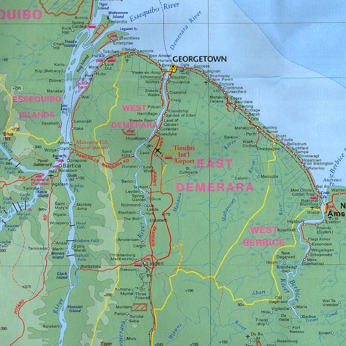
The Guyana coast comprises the river deltas of the Essequibo, Demerera, Mahaica, and Berbice rivers, all of which flow north,
dividing the country into several well defined geographical regions (Fig. 1).
The relative proximity of several major river deltas
and the associated volume of sediment has created a low coast, a portion of which lies below sea level.
The rich, fertile lands of the coastal regions, compared with the thin soils
of the tropical rain forest to the south, has made it possible for human settlement to flourish along the coast. The drainage and irrigation works
necessary to realize the economic potential of the region followed in due course, first under the colonial powers, and since 1964, under
republican governments.
Human habitation grew alongside with agriculture, concentrating much
of the country's rural and urban development within a 25-km wide coastal band.
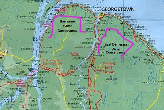
A unique feature of the Guyana landscape is represented by the conservancies, which are large, shallow, storage reservoirs, designed to store water for
both flood control and irrigation. There are two major conservancies:
(1) the Boerasirie Water Conservancy (BWC), located between the Essequibo and Demerera rivers, and (2)
the East Demerera Water Conservancy (EDWC), located between the Demerera and Mahaica rivers.
The design and construction of these
water management systems dates back to the late 1800s. "Conservancy" is the local name given to a large expanse of land, limited downstream by an low
earthen dam, which retains the water for use primarily in irrigation (Fig. 2). Typically, a conservancy
has a number of relief structures (sluices, or "kokers"), which are designed to
release flood waters in times of heavy floods, when the reservoir fills up and the embankment is at risk of impending overtopping.
In particular, the Boerasirie Conservancy also features a 8000-feet long relief weir.
The floods of 2005 have prompted a renewed interest of the GoG and other concerned parties on the integrity and safety of the EDWC and BWC systems.
The current state of disrepair of the embankments and some relief structures,
the near failure of sections of the dams during the flood of 2005, and the uncertainty regarding the relation between
rainfall and floods, relief capacity, tailwater levels, and reservoir sedimentation,
have combined to impose a clear sense of urgency to the task of conservancy rehabilitation.
Lack of reliable data, including rainfall, runoff, sediment loads, and tides,
has contributed to render the situation particularly acute.
A comprehensive fresh look is needed of the hydrology and hydraulics of the two conservancies.
A specific question to be addressed is: What combined relief capacity is needed in each conservancy,
in sluices and/or weirs, to assure the safe passage of a design flood?
The choice of an appropriate design flood to protect Georgetown, the capital
city of Guyana, against the risk of catastrophic flooding involves hydrological, socio-economic, and political considerations.
The hydrologic and hydraulic study is particularly needed because the current system is old, nearly obsolete,
and its 100-yr old design was based on data of dubious quality.
Recent advances in the sciences of hydrology and hydraulics make possible an increased level of certainty regarding the safety of the
EDWC and BWC systems after rehabilitation.
The East Demerara Water Conservancy has a total catchment area of 582 km2.
This estimate is based on catchment delineation
on 1:50,000 scale topographic mapping, and is somewhat larger than the original figure of 518 km2
estimated by Hutchinson in 1951 (Mott MacDonald, 2005a). At an elevation of 17.53 m (57.51 ft),
the reservoir area is 336.7 km2, which is
65% of the total catchment area. The remaining upstream 35% is heavily vegetated and of low relief.
The average slope of the longest stream path is 0.00061
(Mott MacDonald, 2005a).
The existing elevation-area-volume characteristics date back to 1951.
In the past 55 years, it is very likely that the data has changed due to reservoir sedimentation.
Therefore, a new elevation-area-volume characteristics is needed.
The East Demerara Water Conservancy has several relief outlets or sluices,
some to the Demerara River to the west, and others to the Mahaica River to the east.
The western sluices are: (1) Cunha, (2) Land of Canaan, and (3) Kofi. The eastern sluices are: (1) Maduni, (2) Big Lama,
and (3) Small Lama. The capacity of the sluices is affected by the tailwater level, which may vary with tide and flood conditions.
The Land of Canaan Sluice constitutes the main western outlet.
It has five radial gates, each of width 4.877 m (16 ft). Recent measurements show that the sill level is at 16.07 m GD (Guyana Datum).
Historically, the sluice has been fully opened
when the Conservancy water level reaches 17.374 m (57 ft). The gates are lifted clear of the water surface, and a standing wave generally forms
downstream. Tidal conditions result in high tailwater levels which have the effect of drowning the outlet, reducing its discharge capacity. The sluice
can discharge a maximum of 152.22 m3s-1 at
an upstream head of 18.5 m, for downstream heads
up to 17.2 m (Mott MacDonald, 2005b).
The Kofi and Cunha sluices each have a single vertical lift gate of 4.877 m (16 ft). These sluices have been out of operation for a very long time, but in view of
the recent floods, they are now being considered for rehabilitation. Survey information for the sill levels is not available.
The Maduni sluice has a single vertical lift gate of 4.877 m (16 ft). The sill level is at 14.139 m. Historically, the sluice has been fully opened
when the Conservancy water level reaches 17.465 m (57.3 ft). Tidal conditions result in high tailwater levels which have the effect of drowning the outlet,
reducing its discharge capacity.
The sluice
can discharge a maximum of 73.54 m3s-1 at an upstream head of 18.5 m, for downstream heads
up to 17.0 m (Mott MacDonald, 2005a).
The Lama sluice consists of two structures with single vertical lift gates, referred to as the big sluice and the small sluice, with different sill levels and
discharge capacities. The big sluice is 4.877 m (16 ft) wide and the sill level is at 14.315 m; the small sluice is 5.233 m wide and the sill level
is at 15.458 m. Historically, these sluice has been fully opened
when the Conservancy water level reaches 17.465 m (57.3 ft).
The big sluice
can discharge a maximum of 68.89 m3s-1 at an upstream head of 18.5 m, for downstream heads
up to 17.1 m.
The small sluice
can discharge a maximum of 45.81 m3s-1 at an upstream head of 18.5 m, for downstream heads
up to 17.2 m (Mott MacDonald, 2005a).
At an upstream head of 18.5 m, assuming that the Kofi and Cunha sluices operate with the same hydraulic characteristics as the Maduni sluice,
the maximum combined capacity of all the relief sluices of the East Demerara Water Conservancy is 487.54
m3s-1 (based on data from Mott MacDonald, 2005a).
The original design of the East Demerara Water Conservancy dam, dating back to 1874, showed a 10-ft crest width at an elevation of 17.98 m
(59 ft), with side slopes of 1:1. The dams were constructed by hand labor with minimal compaction. The fill material was taken primarily from directly
upstream as part of the excavation of the maintenance canal, with probably little selection of the best soil, or exclusion of the local peat (pegasse)
(Government of Guyana, 2005).
Several portions of the dam are in various states of disrepair, and at risk of overtopping, piping, or sliding.
The dam is about 51.5 km (32 miles), measured from the Land of Cannan relief sluice to the west, to the
Maduni relief sluice to the east (Table 1). Over the more than 100 years of use, there has been significant settlement of the crest, erosion,
and slips of up to 5-ft high in the upstream
slope, the latter over substantial portions of the embankment (Government of Guyana, 2005).
1. INTRODUCTION
2. BACKGROUND


3. THE EAST DEMERARA WATER CONSERVANCY
3.1 RELIEF STRUCTURES
3.2 DAM
| Table 1. East Demerara Water Conservancy dams. | ||
| Dam | Location | Length (km) |
| West | Land of Canaan relief sluice to Nancy Stop-Off | 14.481 |
| North | Nacy Stop-Off to Buxton | 9.654 |
| Northeast | Buxton to Flagstaff | 12.872 |
| East | Flagstaff to Maduni relief sluice | 14.481 |
| Total | Land of Canaan to Maduni | 51.488 |
The January-February 2005 storm crested at 17.92 m (58.8 ft). About 10% of the dam's length was either overtopped or required sandbagging during this storm event. Current plans call for the raising of the crest to a minimum of 18.3 m (60 ft) GD to reduce the risk of overtopping.
In its present form, the East Demerara Water Conservancy represents a serious risk of flooding to a capital city such as Georgetown.
The situation is particularly acute because breaching of the dam delineating the conservancy is bound to cause significant damage to
key urban and agricultural areas located in the narrow coastal band. The situation is compounded by the lack of natural drainage of the coastal band,
portions of which lie at or below sea level.
The hydraulic system of the conservancy is more than 100 years old, and very little has been done in the past to maintain it.
Substantial portions have fallen into disrepair and are sorely in need of overhaul or outright replacement.
Furthermore, very little data or data-gathering capabilities exist to support reasonably adequate analysis and design.
For instance, little is known on local spatial and temporal variability of rainfall, rainfall-runoff transforms, conservancy flow regime (laminar or turbulent),
sedimentation rates, and tidal/flood tailwater conditions.
Thus, it is imperative to perform a comprehensive engineering study to rehabilitate the conservancy
to present standards of practice, enabling it to be operated safely into the future. The study objectives are:
3.3 ASSESSMENT
The following study components constitute a comprehensive plan for the rehabilitation of the East Demerara Water Conservancy.
A survey is required of the entire catchment comprising the East Demerara Water Conservancy.
The objective of the survey is to provide accurate data regarding elevations, areas, and volumes.
The survey should include complete details of all sluice structures, including type, widths, sill levels, and historical operational rules.
This entails a review
of existing practices worldwide, regarding meteorological and/or frequency-based storms for the design of a conservancy-type water-management
system such as the EDWC.
The objective is to choose an appropriate frequency-based storm for dam and sluice design.
A related objective is to determine the recommended freeboard for the chosen
risk level.
A hydrologic study to determine the 50, 100, 500, 1000,
5000, and 10000-yr storms for durations of 1 day, 2 days, 3 days, 5 days, and 10 days. The objective is to provide a range of
hydrologic loadings to drive
the model. A related objective is to provide an assessment of the effect of climatological phenomena such as El Niño and La Niña,
including climate change, on the rainfall characteristics of the
catchment of the East Demerara Water Conservancy.
A hydrologic study of the conversion of rainfall to
runoff in the catchment of the East Demerara Water Conservancy, with the objective of developing a flood hydrograph for the design storm.
A hydraulic study to determine sluice capacities of the existing
outlet structures, under free-flow and high-tailwater conditions. This entails the review of recent studies (Mott MacDonald 2005a, 2005b),
with new information
regarding sill characteristics (levels)
as developed in the proposed study (Item 1).
Development of a routing model to design the crest elevation of the dam to avoid
overtopping under the chosen hydrologic loads. The modeling should consider the following scenarios:
Perform a topographic survey of the entire alignment of the East Demerera Water
Conservancy to determine the existing crest profile and geometry of cross sections at intervals of 100 meters.
Perform a survey of the entire alignment of the East Demerera Water
Conservancy to determine the condition or state of the embankment in terms of its safety against overtopping, piping, and/or sliding.
Determine the new dam crest elevation based on the results of item 6.
Based on the results of items 7 and 8, establish the portions of the embankment in need of repair or replacement.
Design the alignment and typical cross section of the new sections of the embankment. Estimate construction costs for repair or replacement of selected
portions of the existing dam.
Estimate rates of sedimentation in the East Demerara Water Conservancy, in order
to assess the life of the structure. Use field information, including soil sampling and analysis,
to determine historical pattern of reservoir sedimentation. Recommend actions aimed at reducing
the rate of sedimentation if deemed necessary.
3.4 PROPOSED STUDIES
The Boerasirie Water Conservancy has a total catchment area of 436 km2.
This estimate is based on catchment delineation
on 1:50,000 scale topographic mapping, and is somewhat larger than the original figure of 404 km2
estimated by Hutchinson in 1951 (Mott MacDonald, 2005a).
At the spillway crest elevation of 18.684 m (61.3 ft), the area of the conservancy is 254 km2, which is
58% of the total catchment area. The remaining upstream 42% is heavily vegetated and underlain by white sand deposits.
The average slope of the longest stream path is 0.00023 (Mott MacDonald, 2005a).
The existing elevation-area-volume characteristics date back to 1951, and may be out-of-date (Mott MacDonald, 2005a).
In the past 55 years, it is very likely that the data has changed due to reservoir sedimentation.
Therefore, a new elevation-area-volume relation is needed.
There are four relief structures in the Boerasirie Water Conservancy. These are: (1) the Waramia sluice, (2) the 8000-ft relief weir,
(3) the Naamryck sluice, and (4) the Potosi sluice. All flood relief sluices have sill levels at 16.916 (55.5 ft).
The 8000-ft weir has a crest elevation of 18.684 m (61.3 ft). Historically, when the upstream water elevation reaches this last level,
the sluice gates are opened.
The Waramia sluice comprises five (5) gates, each of which is 4.877 m (16 ft) wide. A plaque at the structure, which was
completed in 1958,
indicates that it
has been designed with a discharge capacity of 2000 cfs, equivalent to 56.6 m3s-1.
The calculated discharge rating table shows that this capacity is achieved at the water level of 18.684 m, which coincides with
the crest elevation of the
relief weir. The Waramia sluice is fitted with an energy dissipation system consisting of a segmented
stilling basin and a tail weir, which affect its discharge.
However, backwater effects of the Bonasika river, located downstream, do not appear to affect the discharge through the
structure. Therefore, for a wide range of water-surface elevations, the discharge capacity is likely to be higher than the design value.
Hydraulic calculations indicate values of 132.07 m3s-1 for an upstream head of
20 m (65.6 ft), which is 1.316 m (4.31 ft) above the design water surface elevation (Mott MacDonald, 2005a).
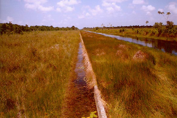
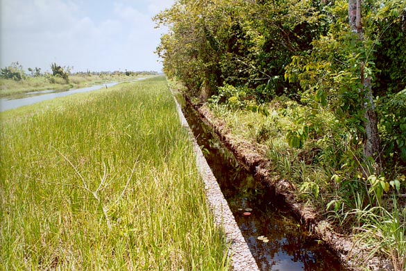
The 8000-ft relief weir is 2438.4 m long (Fig. 3), with a crest width of 152 mm (6 inches).
With a maximum head over the weir of 215 mm, the head-to-width ratio is 1.4, and the weir should behave as a broad-crested weir (Fig. 4).
The discharge coefficient varies from 1.45 at spill level (18.684 m) to 1.78 at the design head of 215 mm (18.899 m).
Using the low value of discharge coefficient (1.45) for safety,
the discharge capacity of the relief sluice varies from 139.69 m3s-1at 18.8 m, to
628.06 m3s-1at 19.0 m,
to 5333.73 m3s-1 at 20.0 m (Mott MacDonald, 2005a).
These calculations assume that the vicinity of the weir is periodically cleared of vegetation growth, which if
left unattended, may impair its performance (Figs 3 and 4).
The Naamryck sluice has a single gate of width 4.572 m (15 ft). When this structure is discharging at full capacity,
it produces backwater in the downstream agricultural drains. The gates at this structure can be lifted clear of the upstream water level, and there
are no backwater influences from the discharge channel, although the tidal gates at the downstream end appear to be in poor repair.
The calculated discharge capacity varies from
19.51 m3s-1at 18.8 m, to
22.70 m3s-1at 19.0 m,
to 40.86 m3s-1 at 20.0 m for a wide range of tailwater conditions
(Mott MacDonald, 2005a).
The Potosi sluice has the same characteristics as the Naamryck sluice. However, there are constraints posed by the downstream channel.
An suitable discharge table for this sluice remains to be developed.
The Boerasirie Conservancy dam is 44.731 km (27.8 miles), measured from the 8000-ft relief weir to the west, to the
Potosi relief sluice to the southeast (Table 2).
The embankments are constructed of good clay material, which is readily available within the conservancy.
Slips in the dams have generally been limited to
small heights on the upstream slopes, mostly from wave action and boat moorings.
The main risk to the dams is overtopping, and this did occur,
albeit to shallow depths, during the January-February 2005 floods (Government of Guyana, 2005).
4. THE BOERASIRIE WATER CONSERVANCY
4.1 RELIEF STRUCTURES


4.2 DAM
| Table 2. Boerasirie Water Conservancy dams. | ||
| Dam | Location | Length (km) |
| West | 8000-ft weir to Naamryck | 16.895 |
| North | Naamryck to Leonora | 9.976 |
| East | Leonora to C-Line | 8.850 |
| Southeast | C-Line to Potosi | 9.010 |
| Total | 8000-ft weir to Potosi | 44.731 |
The January-February 2005 flood crested at 19.25 m (63.17 ft), while the 500-yr flood is calculated at 18.91 m (62.03 ft) and the 1000-yr flood is calculated at 18.92 m (62.07 ft). Clearly, the embankment is unsafe against overtopping. Moreover, the reservoir does not appear to behave as a level pool, judging by the difference in water-surface elevations typically observed between Leonora and the Waramia sluice, close to the 8000-ft weir. Presently, the main canal adjacent to the dam is partially clogged with vegetation growth, obstructing the flow into the 8000-ft relief weir. A pseudo-two-dimensional hydraulic model may be required to properly ascertain the flow conditions for design purposes.
This report
4.3 PROPOSED WORKS
This report
5. CONCLUSIONS
6. REFERENCES
Goverment of Guyana, 2005. East Demerara and Boerasirie Conservancy Dams: Condition assessment by dam specialist. April. http://ponce.sdsu.edu/guyana_condition_assessment_by_dams_specialist.pdf
Mott MacDonald, 2003. Guyana drainage and irrigation systems rehabilitation project. October, Cambridge, UK. http://ponce.sdsu.edu/guyana_drainage_and_irrigation_systems_rehabilitation_project.pdf
Mott MacDonald, 2005a. Draft report on conservancy flood management modelling. May, Cambridge, UK. http://ponce.sdsu.edu/guyana_draft_report_on_conservancy_flood_management_modelling.pdf
Mott MacDonald, 2005b. Conservancy flood management modelling, Model update report. August, Cambridge, UK. http://ponce.sdsu.edu/guyana_conservancy_flood_management_modelling_update_report.pdf
Mott MacDonald, 2005c. Infrastructure Rehabilitation: Short to Medium Term Plan, Final Report, 12 July 2005, Cambridge, UK. http://ponce.sdsu.edu/guyana_infrastructure_rehabilitation_short_to_medium_term_plan.pdf
Mott MacDonald, 2005d. Guyana: Final Report of the Special Advisor, July 2005, Cambridge, UK. http://ponce.sdsu.edu/guyana_final_report_of_the_special_advisor.pdf
Mott MacDonald, 2005e. Infrastructure rehabilitation: Short to medium term plan, June 2005, Cambridge, UK. http://ponce.sdsu.edu/guyana_short_to_medium_term_plan_first_draft.pdf
Unknown, 2005. Guyana: Medium Term Conservancy Works http://ponce.sdsu.edu/guyana_medium_term_conservancy_works.pdf
Kirby, A., P. Meesen, and H. Ogink, 2006. Engineering assessment of 2006 floods, Final Report, February. http://ponce.sdsu.edu/guyana_engineering_assessment_of_2006_floods_main_body.pdf
The World Bank, 2005. Preliminary damage and needs assessment following the intense flooding of January 2005. Draft Report, February 14, 2005. http://ponce.sdsu.edu/guyana_preliminary_damage_and_needs_assessment.pdf
Task Force for Infrastructure Rehabilitation, 2005. Progress report until March 20th, 2005. http://ponce.sdsu.edu/guyana_progress_report_until_march_20th_2005.pdf
Guyana Drainage and Irrigation Systems Rehabilitation Project, 2003. Hydrology and water resources interim review. http://ponce.sdsu.edu/guyana_hydrology_and_water_resources_interim_review_2003.pdf